For Part 107 commercial drone operators — survey/mapping, inspection, real-estate and cinematography
Know your flyable hours before you drive out
Flight windows for your aircraft at your site, with the chance they hold — from up to 146 forecast runs, checked hour by hour.
The costly call
A scrubbed mission costs a day
A scrubbed mission costs a day of drive time, a rebooked client and a crew you still pay. One green icon for "now" does not tell you whether Thursday's 3-hour survey window will hold.
How it works
From your place to an answer
Set up your aircraft and site
Pick your aircraft class and drop a pin on the site.
Choose the mission
Mapping, inspection, golden hour, cinematic or thermal.
See your flight windows
The next flight windows, the chance each one holds, and what is limiting it: gusts, wind aloft, rain, visibility or cold.
In the app
See it on a real forecast
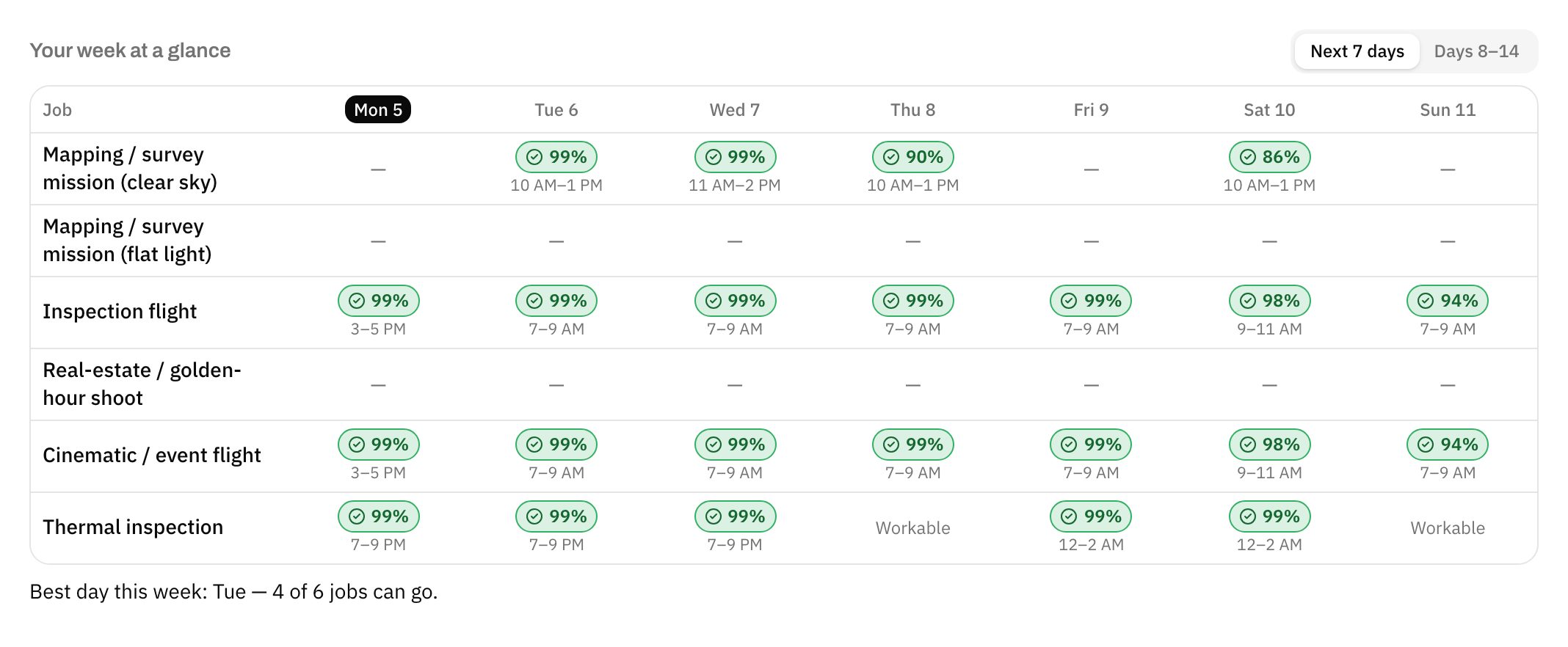
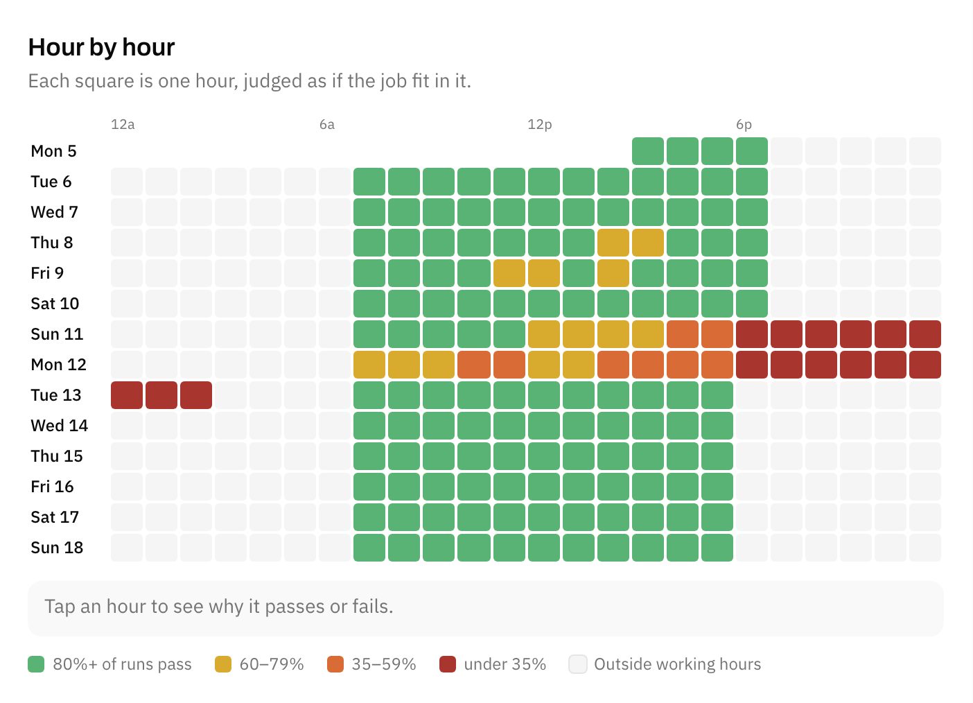
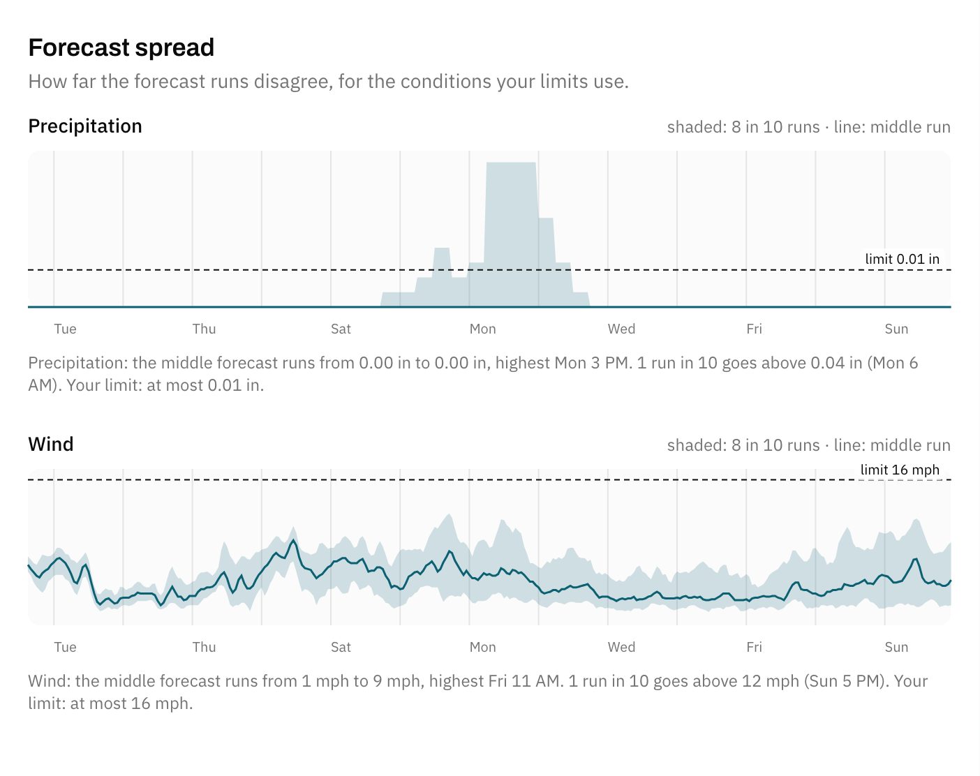
Real forecasts for Phoenix, Sonoran Desert, AZ, captured October 5, 2026. Yours will be for your own place and limits.
What you get
Built for Part 107 commercial drone operators — survey/mapping, inspection, real-estate and cinematography
Flyable hours
Flyable daylight hours per day for your aircraft class, and the chance of a 3-hour flight window.
Wind at altitude
80 m wind against surface wind, with the share of forecast runs under your aircraft's rating. Only some runs publish 80 m wind; the card says how many answered.
Golden hour quality
Cloud and wind for the next 7 sunrises and sunsets, so you book the shoot on the evening worth flying.
Battery temperature
Daylight hours outside your aircraft's operating range, and cold hours when packs need warming.
Clear-sky and flat-light mapping
Separate windows for hard mid-day light and full overcast, so photogrammetry gets the light it needs.
Thermal windows
Night windows after sunset and before dawn, after 24 dry hours, for radiometric roof and solar work.
The missions it times
Mapping / survey mission (clear sky)
Photogrammetry or lidar mission in steady wind and hard, even light with short shadows, 10 am to 3 pm. Cloud cover is one forecast, not a probability. Cloud base is not checked: stay 500 ft below clouds yourself.
3-hour window · daylight only
Mapping / survey mission (flat light)
The same mapping mission flown under full overcast for shadow-free, even exposure. Partly cloudy skies, with moving shadows, fail both mapping missions. Cloud base is not checked: stay 500 ft below clouds yourself.
3-hour window · daylight only
Inspection flight
Roof, tower, bridge, solar or facade inspection flown close to structures, inside your aircraft's wind limits. Cloud base is not checked: stay 500 ft below clouds yourself.
2-hour window · daylight only
Real-estate / golden-hour shoot
Exterior listing photos and video in warm light in the 2 hours before sunset. Stays inside daylight: after sunset is civil twilight and needs anti-collision lighting (14 CFR 107.29). Cloud base is not checked: stay 500 ft below clouds yourself.
1-hour window · daylight only
Cinematic / event flight
Smooth moving shots for film, a commercial or an outdoor event, where steady wind matters more than light. Cloud base is not checked: stay 500 ft below clouds yourself.
2-hour window · daylight only
Thermal inspection
Radiometric roof, solar or building-envelope survey between sunset and sunrise, when solar loading is gone and surfaces have been dry for 24 hours. Night flight needs anti-collision lighting. Cloud base is not checked: stay 500 ft below clouds yourself.
2-hour window
What else it watches
- Flyable hours
- Wind at altitude
- Golden hour quality
- Battery temperature
- Gusts vs. your aircraft's rating
- Heat on the pad
Every answer counts the forecast runs that keep the whole mission inside your limits, at your site.
Founding members
Join the beta — your first six months free
Only 10 founding places: the first 10 Part 107 commercial drone operators — survey/mapping, inspection, real-estate and cinematography to apply get the Drone Pilots edition free for six months when it launches. No card needed. When they're gone, it's the waitlist.
Only 10 founding places.
- Your first six months of the Drone Pilots edition free when it launches
- Early access to the app as it is today
- A say in which missions the Drone Pilots edition times next
Questions
Asked before you start
How is this different from a weather app or UAV Forecast?
They show one forecast. This checks your whole mission window against your aircraft's limits in each of up to 146 ensemble runs and tells you the share that pass, 14 days out.
Does it check Part 107 weather minimums?
Visibility (3 statute miles) yes, from one forecast, with no probability. Cloud clearance (500 ft below, 2,000 ft horizontal) no — cloud base is not in the data. You must check it. Lightning, radar and GPS conditions are not checked either.
Can I keep a record of my go / no-go calls?
Yes. Log a mission window and the decision log keeps the verdict, the share of forecast runs that passed and the conditions the forecast showed, with your note. Export it to CSV whenever you need it.
How sure is the wind at altitude?
It uses 80 m (about 260 ft) model wind as a stand-in for 100–400 ft. Only some forecast runs publish 80 m wind, so its chance is based on fewer runs than the rest, and the card says how many. Gusts aloft are not forecast.
Does it cover airspace or LAANC?
No. Use your airspace app for authorisation.
What data does it use?
It pools up to 146 forecast runs from three independent forecast systems and judges them run by run, plus a single hourly forecast for visibility and cloud cover, refreshed through the day.